What is ecological connectivity?


Ecological connectivity means how easily animals, plants, and resources can move across a landscape. It’s important for keeping nature healthy and making sure different species survive.

When animals and plants can travel and share resources between different places, it helps to:

  • Keep populations strong, healthy and genetically diverse
  • Let species spread out and find new homes
  • Support natural processes like pollination and recycling nutrients

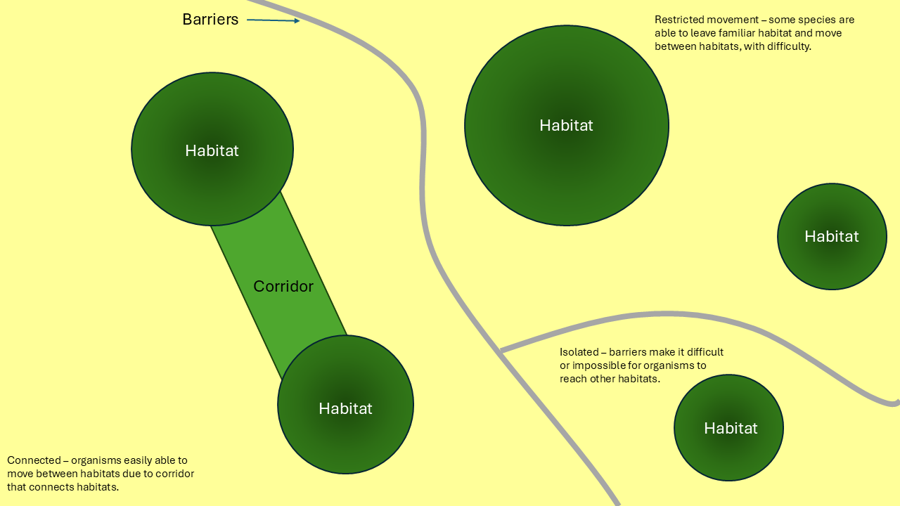
When habitats are broken up into smaller pieces, called habitat fragmentation, it makes it harder for species to move around. This can cause:

  • Smaller populations that are more likely to die out
  • Less variety in genes, which makes species weaker and less resilient to environmental changes
  • Problems with natural processes and services in the ecosystem

There are three ways to think about ecological connectivity: how the land is arranged (structural connectivity), how animals actually move (functional connectivity), and a mix of both physical and actual movement (effective connectivity).

Structural connectivity means the way the land is physically set up to help animals and plants move around. Things like habitat corridors—strips of natural land connecting habitats—make it easier for species to travel from one place to another.

Functional connectivity is about how animals and plants actually move through the landscape. It depends on things like how they behave, the quality of the habitat, and the layout of the land.

Effective connectivity combines both how the land is arranged and how species move. It gives a full picture of how well animals, plants, and resources can travel and interact in an area.

You can also access the form here: Landscape Connectivity Questionnaire – Fill out form

Connectivity Resources

Resource NameOrganization's NameDescription of ResourceType of Resource
Municipal Eco ToolkitMiistakis InstituteInformation
Planning to Connect: A Guide to Incorporating Ecological Connectivity into Municipal PlanningMiistakis InstituteDeveloped by the Miistakis Institute, Planning to Connect provides a guide intended to support municipal planners and those who are affected by municipal plans. The guide includes a Policy Clause Catalogue, which provides example clauses, as well as a document library of cases.Guide
Conecting the Dots: A Guide to Using Ecological Connectivity Modeling in Municipal PlanningMiistakis InstituteA guide prepared by the Miistakis Institute that outlines how planners can acquire and use connectivity mapping to inform planning questions, working in partnership with their GIS colleagues and local biologists.Guide
Pulling the Levers: A Guide to Modelling and Mapping Ecological ConnectivityMiistakis InstituteA companion technical guide to “Connecting the Dots” that describes the process for modelling and mapping ecological connectivity.Guide
Biodiviersity Conservation Strategy, Surrey, BCCity of SurreyDeveloped in 2014, this strategy aims to preserve biodiversity in the City of Surrey, recognizing biodiversity as a key foundation of a health, livable and sustainable community. One of the key principles in this document is to enhance habitat connectivity by establishing natural corridors between habitat patches.Plan
Human-Wildlife Coexistence: Recommendations for Improving Human-Wildlife Coexistene in the Bow ValleyTown of Canmore
Town of Banff
Government of Alberta
This report was developed by a technical working group of local experts and stakeholders to encourage coexistence between wildlife and humans, and to maintain habitat and healthy populations of wildlife across the landscape. Habitat connectivity via wildlife corridors is an important component of human-wildlife coexistence and is discussed in this document.Information
Ottawa Greenspace Master Plan Strategies for Ottawa's Urban GreenspacesCity of OttawaThe purpose of this document is to express Council’s vision for greenspace in the urban area and set policies for how this vision can be pursued. The goal is for there to be an adequate supply of high quality greenspace, linked to allow for movement through green corridors.Plan
Our BiodiverCity: Calgary's 10-year biodiversity strategic planCity of CalgaryThis plan is based on the principle of protection, development and management of Calgary Parks and ecosystems in support of biodiversity. The plan includes monitoring of ecological integrity in the City, including a focus on linkages between habitats.Plan
Riparian Strategy: Sustaining Healthy Rivers and CommunitiesCity of CalgaryThe City of Calgary developed this document to guide the protection, restoration and management of riparian areas in the City. One of the Plan’s goals is ensuring riparian areas are connected, which is critical to protecting riparian health.Guide
Open Space & Trails PlanTown of CanmoreThe guiding principles of Canmore’s open space plan aim to integrate human use and respect for (and maintenance of) wildlife habitat and corridors. Wildlife habitat connectivity (via corridors) is one of the guiding principles.Plan
Green Bylaws Toolkit for Conserving Sensitive Ecosystems and Green InfrastructureThis document is an important resource for understanding how municipalities can safeguard the environment, from a regional to a site level. It clearly explains each tool, and provides case studies and examples of bylaws that are in use in British Columbia. This document explains the importance of mapping green spaces and their ecological connectivity.Information
Green Infrastructure in Calgary's Mobility CorridorsCity of CalgaryThis project report proposes design principles and a related palette of green infrastructure strategies to help Calgary maximize environmental benefits in mobility corridors. The document explains how Calgary’s green infrastructure can enhance urban biodiversity and habitat connectivity in/via its Mobility Corridors.Information
Background Report: Biodiversity-Led Green Infrastructure in a Changing ClimateAdaptation to Climate Change Team, Simon Fraser UniversityThis document combines workshop input, literature review, and case studies of green infrastructure approaches as nature-based solutions to climate change. The case studies are at various scales and designed to communicate the benefits to biodiversity that can be achieved by taking an ecosystem approach to green infrastructure implementation. Connectivity for species is described and case studies in Alberta are included.Information
Pronghorn Connectivity Action PlanMiistakis InstitutePlan
Connecting wildlife habitats for a healthy planetParks CanadaInformation
Central Grasslands Roadmap Initiative
Mapping Resources
Central Grasslands Roadmap InitiativeMap
National priority areas for ecological corridorsParks CanadaMap
Connect: Calgary's Parks PlanCity of CalgaryThis document guides the planning, development, and management of Calgary’s park system. Connectivity for people and wildlife is one of the strategic directions, with 'Protect and Enhance' as an action item to facillitate connectivity.Guide

High Value Landscapes GIS Layer

The High Value Landscape Layer is available as a GIS file.

Please email coordinator@albertapcf.org to request it.

Methods Document:

High Value Landscapes (HVL) mapping layer methodology

Connecting Corridors Webinar ~ October 24, 2019

With the generous support of our Saskatchewan PCAP Partners the webinar provided an opportunity for 60 participants including workshop invitees as well as other interested parties from the PCF/PCAP networks to hear about the following projects:

Watch Video

Connecting Corridors Workshop ~ Airdrie, AB ~ October 29, 2019

Two dozen invited expert participants attended the workshop representing a diverse group including colleagues from Alberta, Saskatchewan, Montana and Idaho. Indigenous peoples were represented by two colleagues from the Kainai First Nation and the Blackfeet Tribe link to participants spreadsheet. Following an introductory presentation to set the scene and recap highlights from the webinar Connecting Corridors Review.Ian Dyson participants spent the day in both plenary and break-out sessions brainstorming on identifying what, where, why and criteria priorities, along with recommendations for priority locations. Following is a summary of 18 surveys that were submitted at the end of the workshop day:

Agenda

Connecting Habitats Report (2017)

In order to build capacity to effectively address the conserving connecting corridors outcome, following a Request for Proposals, the PCF let a contract with 02 Planning and Design Inc. to produce a literature review report focused on prairie and parkland Alberta addressing key habitats to be connected, movement facilitators and inhibitors and mitigation options. The consultant was asked to describe key movement and connectivity characteristics for waterfowl, grassland birds, raptors, amphibians, reptiles, large and small mammals, and plants. The report, “Connecting Habitats in the Prairies of Alberta: What Does This Mean and How Do We Manage For It?” was published in 2017.

PCF Connecting Corridors Work Group:

Following publication of the 02 report, the PCF Board of Directors struck a work group to review the report and craft a path forward.

Current membership of this group is: Ruiping Luo (Chair), Alvin First Rider, Ashlyn Herron, Benjamin Misener, Emily Holden, Ian Dyson, Molly Bannister, Neena Jordan, Robert Sissons, Ron McNeil, Sarah Goodman, Sasha Harriott and Stefano Liccioli, with Samantha Van Ham providing secretariat support. The group identified the need to clarify justifiable spatial priorities as a prerequisite to further meaningful progress and that a 2019 ‘experts workshop’ was needed, focused on ‘what, where and why’.